
- Startsida
- En
- Experience
- Nature and the outdoor life
- The 7 Natural Wonders of Halmstad
The 7 Natural Wonders of Halmstad
The world is full of amazing wonders. created by Mother Nature herself. We have picked out seven natural wonders that epitomise the wide range of nature experiences we have here in Halmstad.
In the forest you will find the cascading Danska Fall waterfall, and from Virsehatt’s vantage point you can gaze out over the broad swathes of forest. In downtown Halmstad you can stroll along the banks of the Nissan river that winds its way through the city; in a few spots the vegetation is so lush that you might imagine yourself to be in a jungle. If you then make your way to the sea, you can enjoy the “endless” beach in Tylösand. Or why not climb the 36 metre-high Lynga sand dune. The Ice Age left its mark in Påarp with the gigantic Slyngestenen boulder. Last but not least, have a seat on the Skallens tron (“the Throne of the Skull”) and survey the sea as you ponder all the wonders we have here in Halmstad.
At the bottom of the page you’ll find a map showing the locations of the various wonders.
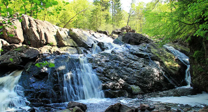
Danska Fall
Danska Fall
The Danska Fall nature reserve is filled with lush forests, babbling watercourses, exciting legends and not least the beautiful eponymous waterfall. An utterly bewitching place! It is the Assman river that runs through the reserve and creates one of Halland’s few waterfalls, with a drop height of 36 metres.
The name “Danska fall” (“the Danish Falls”) derives from a legend. After the Battle of Fyllebro, part of the defeated Danish army fled up the Fylleån river. The Danes were crossing the falls via a suspension bridge when the Swedes struck, chopping through the ropes and causing the Danes to plummet to their deaths.
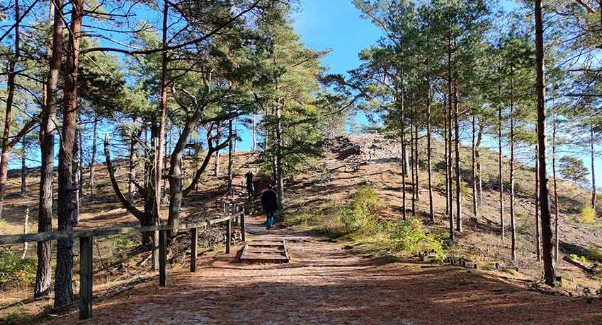
The path up to Lynga sand dune
Lynga sand dune
In Haverdal’s beautiful coastal reserve you will find the Lynga sand dune, also known as “Stora sandkullen” (“the Great Sand Hill”). With a height of 36 metres, the top of the dune offers a fantastic view of the sea, coast and inland area. The dune is considered to be one of the largest in Scandinavia. Its summit is also equipped with benches and tables, making it a perfect spot for a picnic!
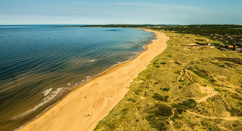
The beach in Tylösand. Photo: Per Nilsson
Tylösand Beach
Tylösand is Halmstad’s flagship beach and has been named Sweden’s best beach on a number of occasions. The beach guarantees unbeatable bathing. On sunny summer days, this nearly four kilometre-long stretch of sand teems with tourists.
Not in the mood for a dip, but still want to experience the lovely beach? Head out for a hike along Prince Bertil's Trail, which runs from Halmstad Castle in the city centre, along the coast out to Tylösand, and then on towards Möllegård.
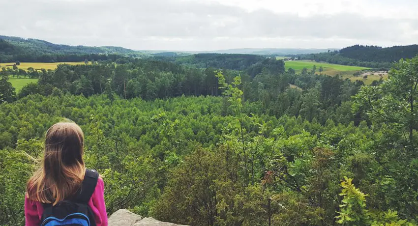
View from Virsehatt. Photo: Åse Ahlstrand
Virsehatt
North of Halmstad, Virsehatt mountain rises like a dome. With its high and even shape, it is easy to distinguish as you approach. Today the area around Viresehatt is a popular nature reserve with several hiking trails, a digital treasure hunt for the kids, good parking and toilets. History buffs can examine the ancient remains of an old castle on the mountain’s summit, gaze at a famous “ättestupa” where our Nordic forebears once committed ritual suicide, and learn about a legend that claims that the mountain is inhabited by trolls. The Sennan river ripples past and the view is magical.
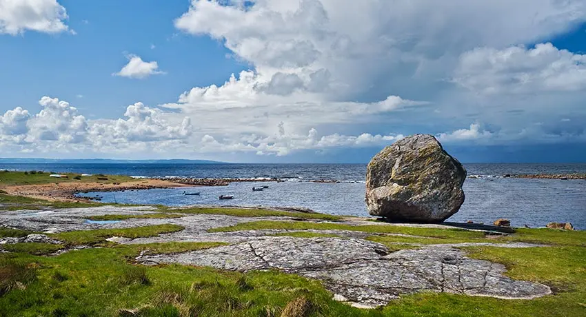
Slyngestenen stone in Påarp. Photo: Patrik Leonardsson
Slyngestenen
Slyngestenen is a 3.5 metre-high boulder located on a rocky outcrop right by the sea, next to the Påarp burial ground. Legend has it that a troll in Söndrum threw the boulder at Eldsberga Church, but it fell short of its target. The boulder has long been used as a landmark for maritime navigation and is now protected as a natural monument.
View from Skallen
Skallen
In the northern part of Haverdal there is the beautiful lookout point known as Skallen (“the Skull”). From here you can enjoy beautiful, sweeping views of the sea, Haverdal Harbour and north towards Falkenberg. In clear weather, you can even see all the way to Kullaberg peninsula in Skåne. The vantage point is a large, open space built up by shards of rock from the quarrying once carried out here. It was exported to Denmark for use as paving stones in the early 20th century. Just southwest of Skallen, at the end of the headland, you will also find one of Halland’s few caves!
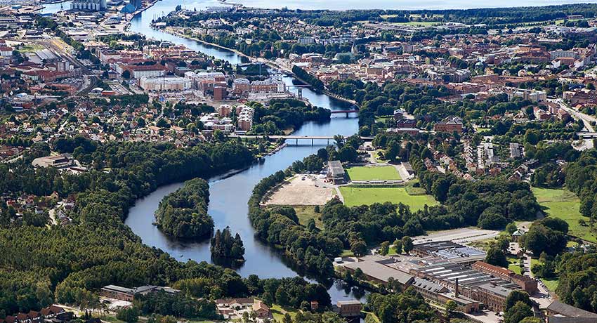
View of Nissan - from Slottsmöllan, through central Halmstad to the sea. Photo: Patrik Leonardsson
Nissan
The Nissan river has its source in the South Swedish highlands, just southwest of Taberg, south of Jönköing, in a bog with the appropriate name of Nissakälla (“Nissan source”). There are several different explanations for the name of the river. For example, the river is said to have been called the Niz during ancient Swedish times, a name that is believed to originate from the Latin verb nitere, meaning to glisten. There is also a theory that it comes from the word nidh or nidwa, which refers to the Nissan’s dark-coloured mossy water. With a length of 186 km, the Nissan is one of southern Sweden’s longest rivers. As early as the 17th century, the famous Halmstad salmon were caught from these waters and exported.
Information in the map is in Swedish. Click the icon in the top right corner of the map to open in Google Maps. To view and hide different layers, as well as to see all visitor destinations, click on the icon in the top left corner of the map.
More wonders and unique tourist attractions
More Halmstad
-
Inspiration and guides
Can I bring my dog to Halmstad? No problem!… -
Nature and the outdoor life
Ahh! The Halmstad air! Filled with the tangs… -
Beach and coast
Shimmering sea and colorful sunsets are only… -
Food and drink
Food and drink is not just food and drink.… -
Culture and history
In Halmstad we deliver both culture and history… -
Events
Theatre? Concerts? Art exhibitions? Sport?… -
Spa and wellness
Taking an invigorating dip in the sea, lacing… -
Shopping
Shopping is an experience in itself. Perhaps… -
The Swedish capital of golf
153 golf holes, eight unique resorts in a… -
Good to know
We have gathered together a few practical… -
Accommodation
Where would you like to stay? In a castle… -
Sports and activities
Do you like being active? Raising your pulse,…