- Startsida
- En
- Experience
- Culture and history
- Halmstad’s fortifications
Halmstad’s fortifications
There used to be fortifications all around the heart of Halmstad. Some remnants of the historic walls can still be seen today.
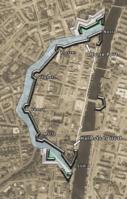
To show the location of the fortifications in relation to today’s Halmstad, the sketch superimposes the walls and moat on a 2019 map of the city.
Building of the fortifications begun
Building of Halmstad’s fortifications is said to have started in 1598. The work is reputed to have been led by Dutch construction manager Hans van Steenwinckel (who is also associated with the fortifications at Varberg, Akerhus and Bohus). Unfortunately, von Steenwinckel died in 1601, four years before Halmstad’s fortifications were completed.
Fortification anatomy
The fortifications comprised high earth embankments surrounded by stone walls. Known as bastions, the pointed projections were platforms for the fortifications’ artillery. These bastions had their own names – Norra (northern), Kloster (monastery), Våghals (daredevil), Västra (western), Mölle (mill) and Södra (southern). A moat and the Nissan river ran around the fortifications.
The fortifications had four gates – Norre port (north gate), Väster port (west gate), Söder port (south gate) and Öster port (east gate). Even today, the north gate has a stately presence.
On the north and northwestern sides of the fortifications, there were two high earthworks for long-range artillery. These were known as “katter” (“cats”). It is believed they were built from earth removed in constructing the moat.
Still here
Even today, you can see the “west cat” at the junction of two central streets (Byggaregatan and Hantverksgatan). The north gate and parts of the “north cat” can still be seen at Norre Katts park.
Also still visible are the old casemates (inset gun emplacements) along Karl XI:s väg. At Klammerdammsgatan, there is an open casemate and at Kyrkogatan there is one that can be viewed from the outside.
More culture and history
-
Hiking along the Nissan River
Head out on a beautiful and interesting walk… -
Scary Places
As the autumn darkness creeps in and the… -
Midsummer in Halmstad
Midsummer is Sweden’s major summer festival.… -
Heritage in Kvibille
Around 15 kilometres north of Halmstad, there… -
Ingrid Wallberg – pioneering architect
Do you know what several of the buildings… -
Museums in Halmstad
In Halmstad there are a number of interesting… -
Historic places within the walls
Halmstad City has several historic places… -
Historic city walk
Join us on a historic city walk in central… -
Centre of Viking culture
700 – 1100. Some 1,000 years ago, Halland… -
The TV Serie "Our Time is Now" – the aunt in the attic
Did you known that Haverdal resident Johan… -
Grötvik – a culture and activity gem
About five kilometres outside the university,… -
Historic highlights in Halmstad
Take a deep dive into Halmstad's history… -
Beautiful churches in Halmstad
There are several beautiful church buildings… -
The 7 Wonders of Halmstad
The world has its seven wonders. And here…
More Halmstad
-
Inspiration and guides
Can I bring my dog to Halmstad? No problem!… -
Nature and the outdoor life
Ahh! The Halmstad air! Filled with the tangs… -
Beach and coast
Shimmering sea and colorful sunsets are only… -
Food and drink
Food and drink is not just food and drink.… -
Culture and history
In Halmstad we deliver both culture and history… -
Events
Theatre? Concerts? Art exhibitions? Sport?… -
Spa and wellness
Taking an invigorating dip in the sea, lacing… -
Shopping
Shopping is an experience in itself. Perhaps… -
The Swedish capital of golf
153 golf holes, eight unique resorts in a… -
Good to know
We have gathered together a few practical… -
Accommodation
Where would you like to stay? In a castle… -
Sports and activities
Do you like being active? Raising your pulse,…

